CHIANG MAI — 31 March 2026, Wildfires have been reported across multiple mountain areas of Chiang Mai, with blazes likened to “volcanoes erupting” on mountain ridges, as communities across the province grapple with heavy smoke and worsening air quality.
Overnight from 30 March into the early hours of 31 March, residents in several districts reported forest fires burning across high hillside terrain, casting a red glow visible from afar. A local resident in Doi Saket district said flames were clearly visible from their home as fires spread across mountain slopes.
Another resident reported capturing images of a distant wildfire in Luang Nuea subdistrict, Doi Saket, at 01:00, showing large sections of forest ablaze.
Separate reports indicated that fires had spread extensively across Doi Luang, with no authorities yet able to reach the area to contain the blaze.
Fires have also been reported in several other mountainous areas, while Chiang Mai city and surrounding districts remain blanketed in hazardous haze, affecting public health across communities.
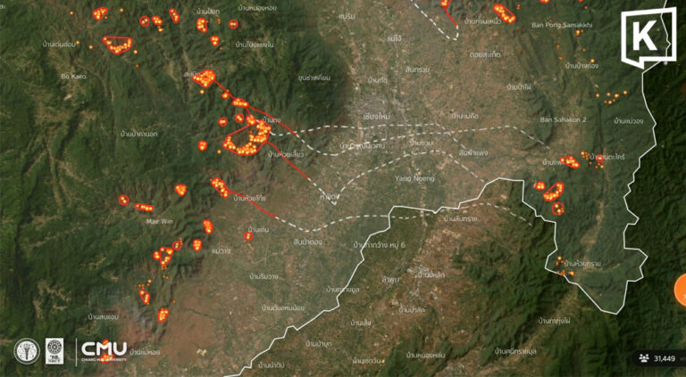
According to the Geo-Informatics and Space Technology Development Agency (GISTDA), 303 hotspots were detected in Chiang Mai as of the morning of 31 March 2026.
- Samoeng — 42 spots
- Mae Taeng — 42 spots
- Phrao — 41 spots
- Chiang Dao — 35 spots
- Mae Wang — 20 spots
- Hang Dong — 19 spots
- Doi Saket — 18 spots
- Hot — 16 spots
- Doi Tao — 14 spots
- Chai Prakan — 8 spots
- San Kamphaeng — 8 spots
- Chom Thong — 7 spots
- Mae On — 6 spots
- Doi Lo — 5 spots
- Mae Chaem — 5 spots
- Galyani Vadhana — 3 spots
- Omkoi — 3 spots
- Mae Ai — 3 spots
- Wiang Haeng — 3 spots
- Fang — 3 spots
- San Sai — 2 spots
Cumulative hotspot data from 1 January to 30 March 2026 shows a total of 4,735 hotspots recorded across the province.